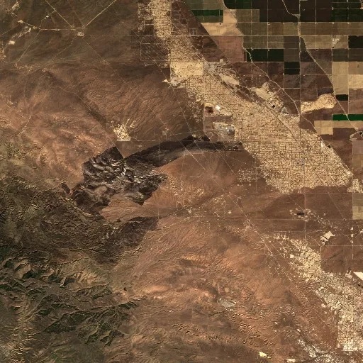
 True view
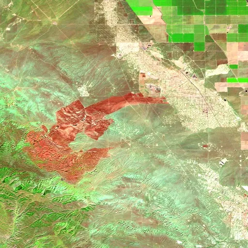
Fire view
Fire view (right): infrared (SWIR), sees through smoke and brings out the heat.
🟢 green = vegetation
🟤 brown = already burned
🟠 orange = fire right now
Drag to compare: normal photo on the left, heat brought out on the right.
Green: vegetationBrown: already burnedOrange: fire right nowSentinel-2 · Copernicus
Red dots: heat detected by satellite in the last 48h. NASA FIRMS
Key facts
Source: NIFCGlossary: what each term means
Barely moving. Low, thin smoke.
Burning without flame, in the ground or in roots. Can flare up days later.
Moves slowly, hugging the ground.
Spreads with low, steady flames.
Spreading evenly and steadily, with visible flame.
Fast and unpredictable.
Runs along the ground much faster than a person walks.
Grows along the sides, not head-on.
Moves against the wind or downhill, which makes it slower.
Climbs into the treetops and jumps crown to crown. It can't be attacked from the ground.
Climbs into the crowns in bursts and drops back down.
Whole trees flaring up like torches.
Single scattered trees flaring up whole, like torches.
Whole clumps of trees flaring at once.
Wind carries embers through the air and starts new fires ahead of the front: that is how a fire jumps a road or a firebreak.
The wind pushes it in long runs in one direction.
The ones marked ● are the behaviors that make a fire harder to stop. They are not a warning or an instruction: they are the description written by the agency in charge. For decisions, always follow your emergency services.
The story so far
After burning for 149 days across Kern County, California, the Lost Fire has been successfully contained. Located 35 miles west of Bakersfield, the incident spanned 7,834 acres of private land featuring tall grass standing 2.5 feet high. Throughout its lengthy duration, the fire exhibited an average daily growth of about 53 acres per day. Fire behavior at the site has been reported as minimal, creeping, and smoldering.
Operations to manage and contain the incident involved 35 personnel operating under a Type 4 Incident complexity and Type 4 IC management. The total cost to suppress the Lost Fire reached about $500,000. The incident began on June 18, 2026, arriving near the end of the region's typical fire season which spans from June to October.
Nationwide, the broader wildfire context shows that 3,540,413 hectares have burned so far in 2026, marking a figure that is 35% below the two-decade average for the country.
In context
This wildfire has been burning in California for 149 days. So far it has affected roughly 7,834 acres — about 32 km². The perimeter is 100% contained.
In the Northern Hemisphere, wildfire activity usually peaks during the warm, dry months — roughly May through October.
The bigger picture in United States
Across United States, roughly 3,540,413 hectares have burned so far in 2026 — 35% below the two-decade average. Data from Copernicus GWIS.
Follow this fire
We'll email you if it grows, if it gets more contained, or if it goes out.
At most one alert every 6 hours, and only when something changes. No account, one-click unsubscribe. Privacy
Or get alerts for any new fire near here → United States todayLive
Community reports
Reports from people near the fire · unverified
Be the first to report what is happening →
Not official emergency information. In an emergency, contact fire services/authorities.
More fires in California
See all Rock FireEnded · 12,008 acres
 Gann FireEnded · 10,339 acres
 Elephant FireEnded · 13,930 acres
 Bryson FireEnded · 200 acres
 Henderson FireEnded · 3,260 acres
 Norte FireEnded · 570 acres